

DISTRICT PROFILE
DETAILS OF THE DISTRICT
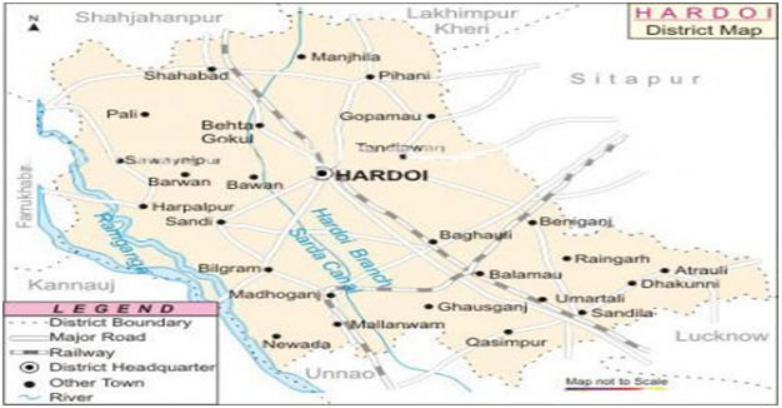
Hardoi district is a district of Lucknow Division of Uttar Pradesh. It lies between 26'-53" to 27"-31'N and 79'-41" to 80'-46" E. Its north border touches Shahjahanpur & Lakhimpur Kheri Districts. Lucknow and Unnao are situated at the south border, west end of the district is surrounded by Kanpur & Farrukhabad and on the eastern end Gomti river separates the district from Sitapur District. �Hardoi comprises of 5 tehsils (Hardoi, Shahabad, Bilgram, Sandila & Sawayajpur), 19 blocks, 191 Nyay, Panchayat, 1101 Gram Sabha & 1901 habited revenue villages. It also has 7 Nagar Palika Parishads & 6 Nagar Panchayats. Geographical area of the district is around 5947 sq. km. As per census 2011, Population of the district is 40,91,380, out of which Female are 18,87,116 & Male are 22,04,264.
History
According to general convention, Hardoi district is related with "HIRNAKASHYAP". Its present name Hardoi is a distorted version of its earlier name "HARIDROHI ". According to Hindu theology, in the past it was ruled by a king Hiranyakashipu, who didn�t have faith in God, but instead declared himself as God. �
According to some scholars, the term �Hardoi� originated from the term �Haridwaya� which means two gods. Since there were two gods, Vamana Bhagavan (in the regime of King Bali) and Narasimha Bhagavan (in the regime of King Hiranyakashipu) had been incarnated hence the place called Haridwaya. Mallawa, Bilgram, Pihani, Shahabad, Sandila & Ruiyaa are the places of historical significance. According to some historians Mallawa was colonized by Buddhists while some believed that Sayyed Salar Masood Gazi came here. Earlier Mallawa was the district headquarters. The ancient name of Bilgram is "SRINAGAR" its present name, was given by some associates of Mahmood Gajnavi. Pihani is derived by persian word Pinhani (place of shelter), it is believed that king of Moughal dynasty Humayun took shelter in the forest of Pihani when he was defeated by Shershah Suri. Pihani is also related with the minister Sadarejahan of Emperor Akbar. His tomb and paintings are still seen here. According to some natives, Sandila was colonized by Rishi Sandilya the place is also famous for old buildings, mosque & barakhamba.
�
�
Micro-farming situations
a) Characteristics
|
S. No. |
Agro-Ecological situations (AES) |
Existing Farming System (Crop+ livestock+ others) |
Major soil types |
|
1. |
Zone�IV Central Plain zone |
Agriculture |
Sandy loam to Clay loam, Saline Alkali and Calcareous |
|
Agriculture + Horticulture |
Sandy loam to Clay loam, Saline Alkali and Calcareous |
||
|
Horticulture |
Sandy loam to Clay loam, Saline Alkali and Calcareous |
||
|
Livestock |
Sandy loam to Clay loam, Saline Alkali and Calcareous |
||
|
Agriculture + Livestock |
Sandy loam to Clay loam, Saline Alkali and Calcareous |
||
|
Agriculture + Livestock + Horticulture |
Sandy loam to Clay loam, Saline Alkali and Calcareous |
||
|
Agriculture+ Allied |
Sandy loam to Clay loam, Saline Alkali and Calcareous |
�
b) Land Characteristics
|
S.No |
Agro-Ecological Situation (AES) |
Topography |
Drainage |
|
1. |
AES- Zone�IV Central Plain zone |
Undulated & Plain |
Surface drainage system |
�